


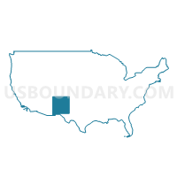
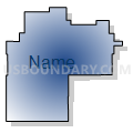
Central Southeast New Mexico PUMA, New Mexico
About
Outline

Summary
| Unique Area Identifier | 193446 |
| Name | Central Southeast New Mexico PUMA |
| State | New Mexico |
| Area (square miles) | 17,533.93 |
| Land Area (square miles) | 17,509.57 |
| Water Area (square miles) | 24.36 |
| % of Land Area | 99.86 |
| % of Water Area | 0.14 |
| Latitude of the Internal Point | 33.16265980 |
| Longtitude of the Internal Point | -105.22170450 |
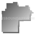
Maps

Graphs
Select a template below for downloading or customizing gragh for Central Southeast New Mexico PUMA, New Mexico


Neighbors
Neighoring Public Use Microdata Area (by Name) Neighboring Public Use Microdata Area on the Map
- Doña Ana County (Outer) PUMA, NM
- Eastern Plains New Mexico PUMA, NM
- El Paso City (North) PUMA, TX
- El Paso County (Outside El Paso City)--Socorro & Horizon Cities PUMA, TX
- Far Southeast New Mexico PUMA, NM
- Rio Grande COG & Permian Basin Regional Planning Commission (West) PUMA, TX
- Southwest New Mexico PUMA, NM
Top 10 Neighboring County (by Population) Neighboring County on the Map
- El Paso County, TX (800,647)
- Doña Ana County, NM (209,233)
- Chaves County, NM (65,645)
- Lea County, NM (64,727)
- Otero County, NM (63,797)
- Eddy County, NM (53,829)
- Lincoln County, NM (20,497)
- Roosevelt County, NM (19,846)
- Socorro County, NM (17,866)
- Torrance County, NM (16,383)
Top 10 Neighboring County Subdivision (by Population) Neighboring County Subdivision on the Map
- El Paso East CCD, El Paso County, TX (160,404)
- El Paso Northwest CCD, El Paso County, TX (78,624)
- Roswell CCD, Chaves County, NM (48,143)
- Alamogordo CCD, Otero County, NM (40,933)
- Carlsbad CCD, Eddy County, NM (33,626)
- Anthony CCD, Doña Ana County, NM (29,822)
- Artesia CCD, Eddy County, NM (17,725)
- Lovington CCD, Lea County, NM (14,624)
- Ruidoso CCD, Lincoln County, NM (14,621)
- Southeast Otero CCD, Otero County, NM (13,108)
Top 10 Neighboring Place (by Population) Neighboring Place on the Map
- El Paso city, TX (649,121)
- Roswell city, NM (48,366)
- Alamogordo city, NM (30,403)
- Chaparral CDP, NM (14,631)
- Ruidoso village, NM (8,029)
- Holloman AFB CDP, NM (3,054)
- Tularosa village, NM (2,842)
- Ruidoso Downs city, NM (2,815)
- La Luz CDP, NM (1,697)
- Boles Acres CDP, NM (1,638)
Top 10 Neighboring Unified School District (by Population) Neighboring Unified School District on the Map
- El Paso Independent School District, TX (327,212)
- Ysleta Independent School District, TX (192,840)
- Socorro Independent School District, TX (179,910)
- Las Cruces Public Schools, NM (149,482)
- Gadsden Independent Schools, NM (62,675)
- Roswell Independent Schools, NM (58,520)
- Alamogordo Public Schools, NM (43,326)
- Clint Independent School District, TX (41,811)
- Carlsbad Municipal Schools, NM (33,835)
- Artesia Public Schools, NM (18,220)
Top 10 Neighboring State Legislative District Lower Chamber (by Population) Neighboring State Legislative District Lower Chamber on the Map
- State House District 75, TX (219,408)
- State House District 79, TX (147,172)
- State House District 74, TX (143,566)
- State House District 53, NM (36,271)
- State House District 50, NM (31,808)
- State House District 49, NM (31,024)
- State House District 52, NM (30,570)
- State House District 62, NM (30,322)
- State House District 54, NM (30,120)
- State House District 66, NM (29,720)
Top 10 Neighboring State Legislative District Upper Chamber (by Population) Neighboring State Legislative District Upper Chamber on the Map
- State Senate District 19, TX (766,044)
- State Senate District 29, TX (758,901)
- State Senate District 37, NM (66,562)
- State Senate District 42, NM (50,650)
- State Senate District 41, NM (48,782)
- State Senate District 31, NM (48,313)
- State Senate District 30, NM (48,188)
- State Senate District 40, NM (46,725)
- State Senate District 32, NM (46,022)
- State Senate District 34, NM (45,445)
Top 10 Neighboring 111th Congressional District (by Population) Neighboring 111th Congressional District on the Map
- Congressional District 23, TX (847,651)
- Congressional District 16, TX (757,427)
- Congressional District 1, NM (701,939)
- Congressional District 3, NM (693,284)
- Congressional District 2, NM (663,956)
Top 10 Neighboring Census Tract (by Population) Neighboring Census Tract on the Map
- Census Tract 9.02, Otero County, NM (9,941)
- Census Tract 18.04, Doña Ana County, NM (6,965)
- Census Tract 4.02, Otero County, NM (6,888)
- Census Tract 9604, Lincoln County, NM (6,771)
- Census Tract 3, Chaves County, NM (6,529)
- Census Tract 9606, Lincoln County, NM (6,300)
- Census Tract 7, Otero County, NM (6,143)
- Census Tract 11.01, Chaves County, NM (6,099)
- Census Tract 8, Chaves County, NM (5,732)
- Census Tract 7, Eddy County, NM (5,179)
Top 10 Neighboring 5-Digit ZIP Code Tabulation Area (by Population) Neighboring 5-Digit ZIP Code Tabulation Area on the Map
- 79938, TX (53,520)
- 88310, NM (35,776)
- 88220, NM (33,725)
- 88203, NM (31,561)
- 88201, NM (25,490)
- 79934, TX (19,174)
- 88210, NM (17,217)
- 88081, NM (15,708)
- 88260, NM (14,343)
- 88345, NM (8,845)